
![]()
Washington Sections
These maps of Washington Section H are produced in 1:50,000 scale, and each map will cover a trail segment of about fifteen miles. Each map image is approximately 300KBytes in size, and will print at approximately 8" x 13.5", at 150dpi. You should be able to print these maps on any average quality color inkjet printer using 8.5" x 14" paper.
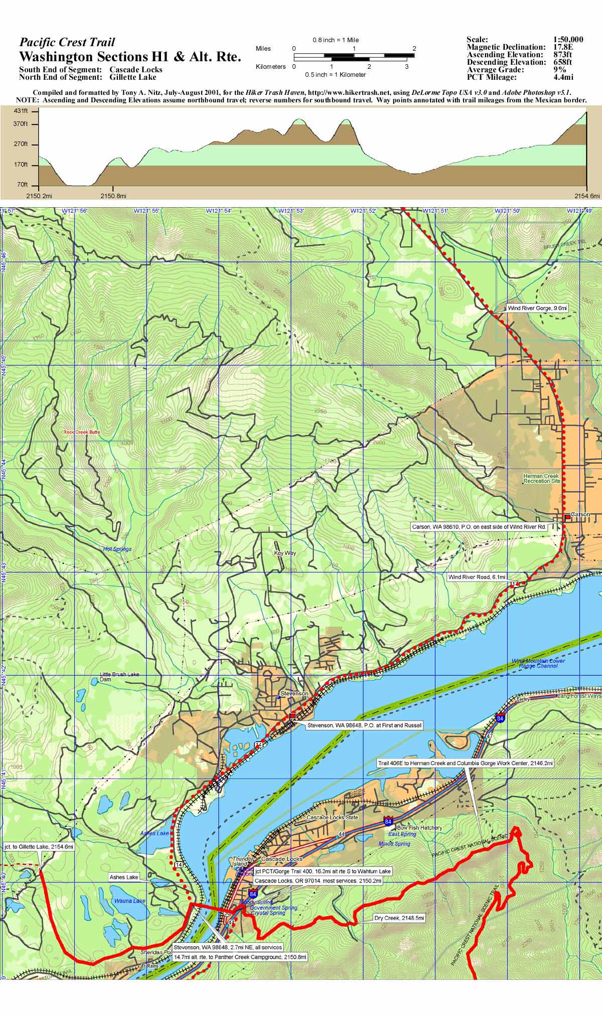
Sections H1, plus alternate Carson route, Cascade Locks to Gillette Lake, 4.4 miles
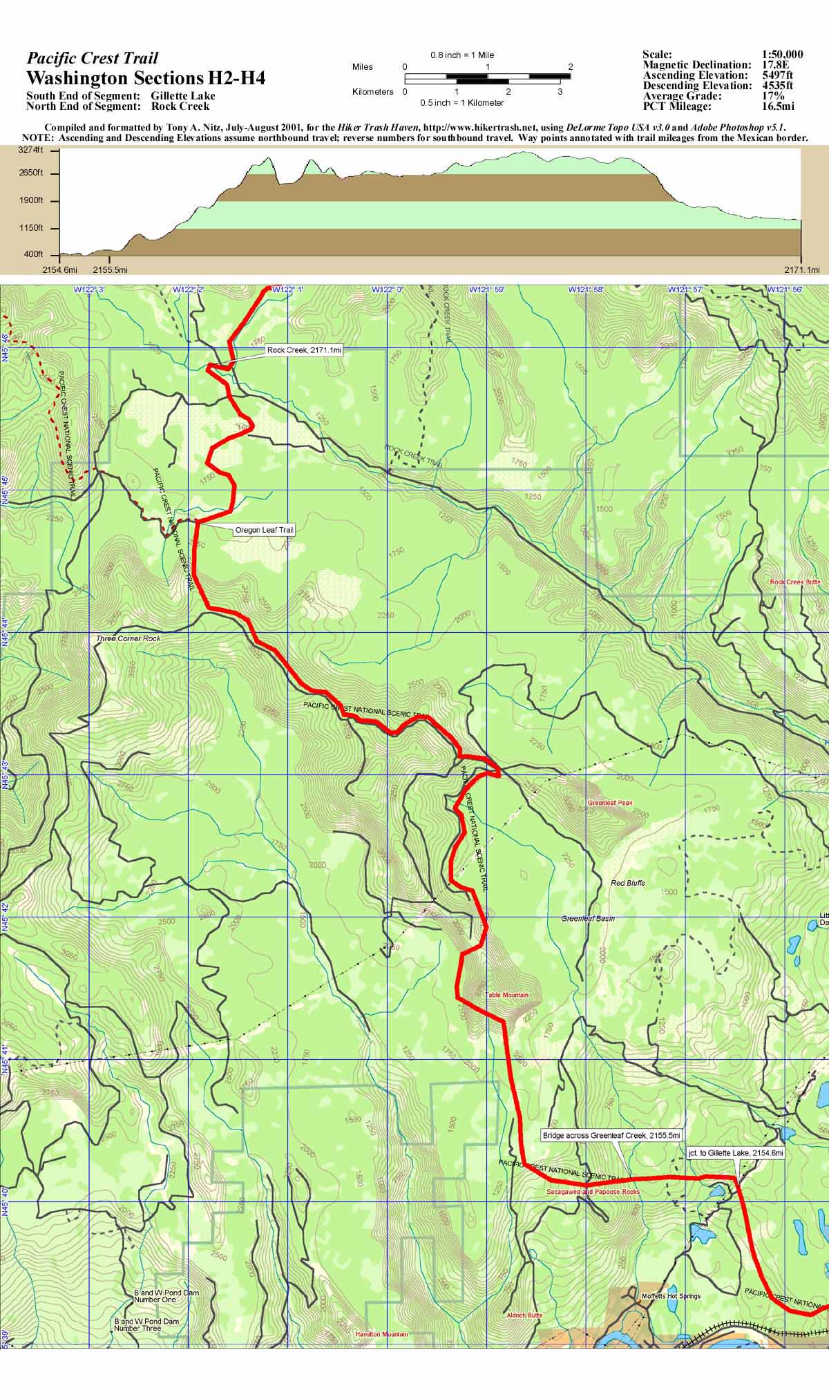
Sections H2-H4, Gillette Lake to Rock Creek, 16.5 miles
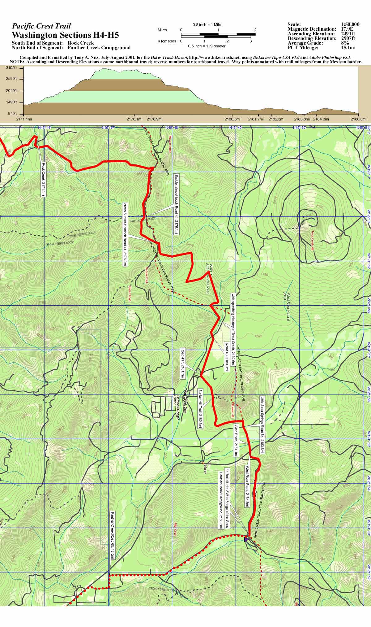
Sections H4-H5, Rock Creek to Panther Creek Campground, 15.1 miles
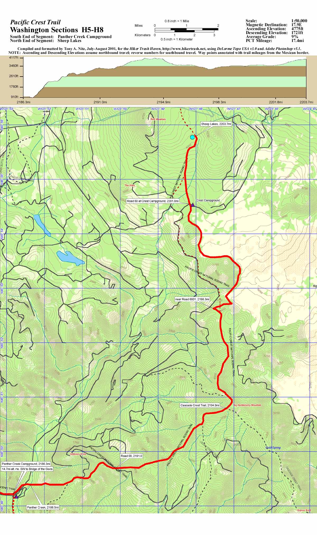
Sections H5-H8, Panther Creek Campground to Sheep Lakes, 17.4 miles
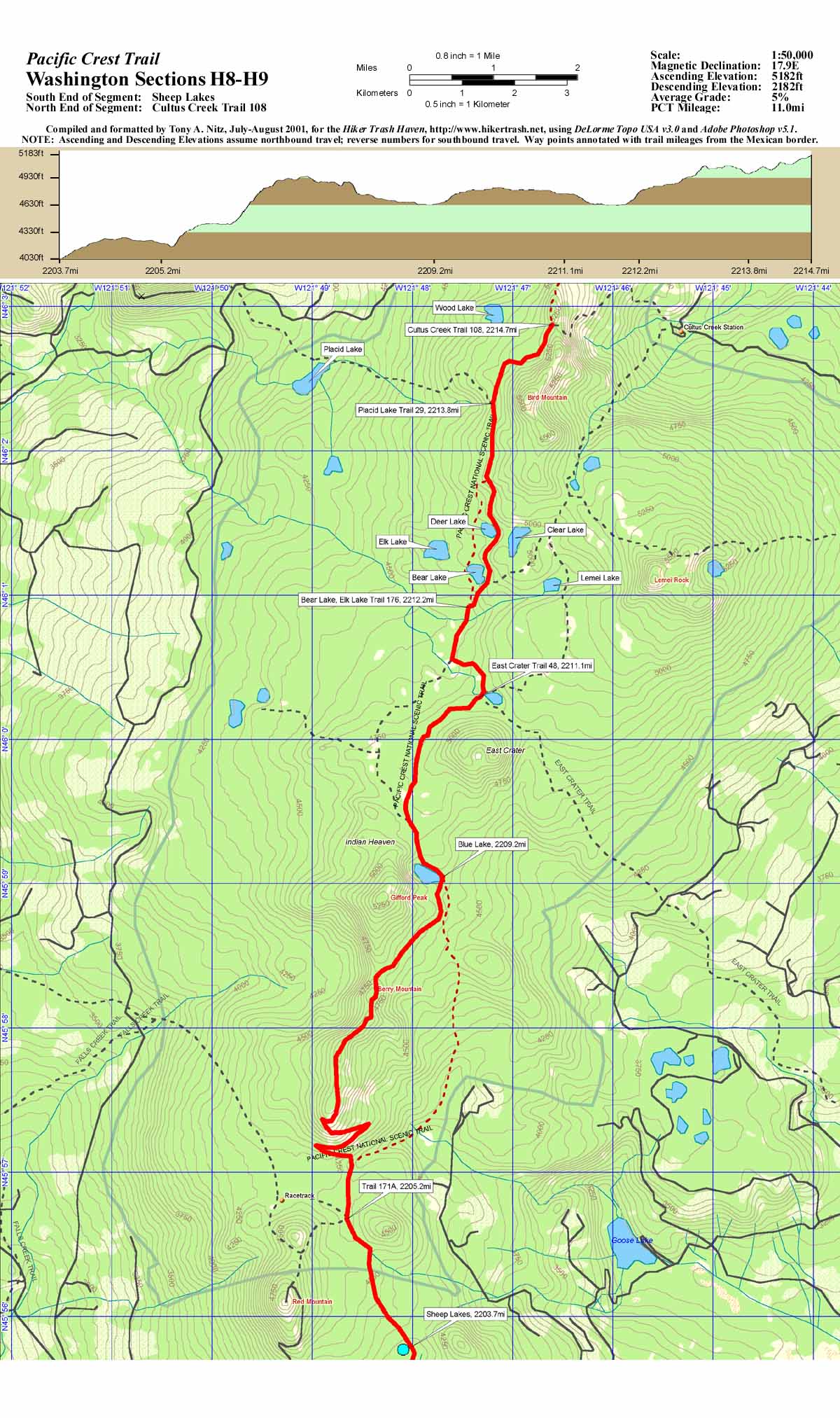
Sections H8-H9, Sheep Lakes to Cultus Creek Trail 108, 11.0 miles
Sections H9-H12, Cultus Creek Trail 108 to Road 8810, 15.1 miles
UPDATE!!! After being stalled by the 9/11 attacks nearly eight years ago, I'm finally heading back out to finish my PCT hike! In preparation for hiking those last 187.1 miles, I finally completed the Washington map sections K and L. I am taking a different tact in this latest generation of maps, however. I am now producing the completed map page in PDF format. This should alleviate any formatting and printing problems that existed in the past with the other sections that are posted in JPEG format. Eventually, hopefully during this winter, I should have all the PCT maps completed and posted in PDF format. The maps for Washington Sections K and L listed below are still produced in 1:50,000 scale. Each map will cover an average of about 10 miles. Each PDF file is formatted to an 8.5 x 11 inch page from a 150dpi image and is about 850kB in size.
Sections K1-K2, Stevens Pass to Lake Janus, 9.5 miles
Sections K2-K4, Lake Janus to Saddle Gap, 13.1miles
Sections K4-K6, Saddle Gap to Lower White Pass, 11.7 miles
Sections K6-K8, Lower White Pass to Sitkum Creek, 11.4 miles
Sections K8-K9, Sitkum Creek to saddle on Vista Ridge, 18.6 miles
Sections K9-K11, Saddle on Vista Ridge to Miners Creek, 11.9 miles
Sections K11-K12, Miners Creek to Hemlock Camp, 9.5 miles
Sections K12-K13, Hemlock Camp to Trapper Creek, 8.2 miles
Sections K13-K14, Trapper Creek to Berry Creek, 10.8 miles
Sections K14-K15, Berry Creek to Twisp Pass Trail, 7.6 miles
Sections K15-L1, Twisp Pass Trail to Cutthroat Pass, 10.3 miles
Sections L1-L3, Cutthroat Pass to West Fork Methow Trail, 13.3 miles
Sections L3-L4, West Fork Methow Trail to Hearts Pass, 12.1 miles
Sections L4-L5, Hearts Pass to Jim Pass, 8.1 miles
Sections L5-L6, Jim Pass to Rock Pass, 9.3 miles
Sections L6-L7, Rock Pass to Hopkins Pass, 7.9 miles
Sections L7-L8, Hopkins Pass to U.S.-Canada Border, 6.6 miles
Sections L9, U.S.-Canada Border to Manning Provincial Park, 7.2 miles
![]()
![]()
![]()
|
|
Hiker
Trash Haven copyright © 1997-2009 by Nitz Technologies, LLC. All rights reserved. Advertising and privacy policies. Revised: Tuesday, 28 July 2009 15:19 +0300 Pages published on this site were tested using Netscape v6.2 and Microsoft Internet Explorer v6. |